About Sedna & KML coordinate musings
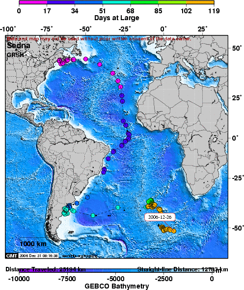
As I said in my previous post - there have been no further updates since boxing day on the shearwater whose progress I've been following. Knowing that GPS receivers don't transmit very well underwater, I had somehow just assumed that was the most likely cause - either by the device coming off, or a tragic event befalling our Sedna.
I emailed the team over at seaturtle.org and they had a far simpler, more obvious explaination.
There is a simple reason that you have stopped getting updates
on the shearwater tracks...batteries. Turtles are large and able to carry
transmitters with large batteries that will last a long time. Birds,
unfortunately, can only be tracked with short-lifespan tags due to weight
limitations. Sedna's battery was supposed to last only 90 days and we tracked
her for 118 days which we were very happy about!
Cheers, Rob
Good stuff!
Also for my geoinformatics essay I'm looking at a limitation within KML. Related to my dissertation on the Gazetteer for Scotland we are having a few issues converting from other map projections into what I assume to be GE projection datum (WGS84?). Wouldn't it be great if we could somehow auto-calculate/convert from say, British National Grid, straight into lat long coordinates. Sadly, it all doesn't seem quite as simple.. though the OS does a great booklet explaining some of the problems and limitations.
Finally, a great link I found to using virtual globes in the classroom.
Labels: kml, projections, Sedna
posted by Jan at
20:35
![]()


10 Comments:
LgDsWA The best blog you have!
olzUF0 actually, that's brilliant. Thank you. I'm going to pass that on to a couple of people.
Nice Article.
Nice Article.
Magnific!
Hello all!
Hello all!
Wonderful blog.
actually, that's brilliant. Thank you. I'm going to pass that on to a couple of people.
Please write anything else!
Post a Comment
Links to this post:
Create a Link
<< Home