Monday, 7 December 2009

We're moving!

OK - so I haven't blogged for, well, ages. The last year has been unbelievably busy and frantic. However I've rather missed blogging about this and that, so I've decided to resurrect this blog for at least a few months and see how things go.

First of all, I'm changing the slant of the blog slightly. It will still focus on much of what it did before. However the focus in particular is going to move closer towards available online sources of mapping and map data - rather than a particularly wide range of GIS type stuff it covered before. While I may cover all sorts of digital cartography related things, I think in particular I am interested in those that are also available as web services for use in other applications.

As a secondary focus, I am now living in South Queensferry. I love it here, and things are about to get even more exciting. A new Forth Road bridge is planned for construction over the next decade or so. It will be interesting to see what kind of 'new media' coverage there will be of this project.

Finally, I am hoping to move across to the wordpress platform. It's something I've toyed with for a while, but I've never really had the time to take the plunge. Don't get me wrong, blogger has been great for blogging, but I hope the new site will be much more than a blog - a categorised list of online cartography, digital maps, web map services and examples of the best mashups that tie all of them together.

So just to ease everyone in, today I saw posted on BBC News that the British Geological Survey has launched a website allowing free access to their repository of geological maps. Not only are there website based viewers, this one built on ESRI software, there are also KML feeds for use in Google Earth and Maps and even a free (for non-commercial use) WMS. Although admittedly this has been down for most of the day, presumably under heavy traffic from the BBC posting. Finally, and this is nearly unheard of from a public body, the entire dataset can be downloaded as digital map files in shape or tab file format for use in your favourite GIS.
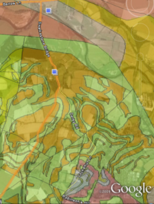
bgs screenshot
Of course, it's not all there yet - all of the detailed data down to 1:10k level is still only available under license and it won't surprise you that any off-shore data is not included. Still - I'd love to see this free data used in any examples.
Labels: , , , , ,

Sunday, 20 April 2008

The views from Schiehallion

This weekend I needed to get out of the city so I went for a clamber up Schiehallion (1083m) up in Highland Perthshire, just North of Aberfeldy, overlooking Loch Tummel & Loch Rannoch.

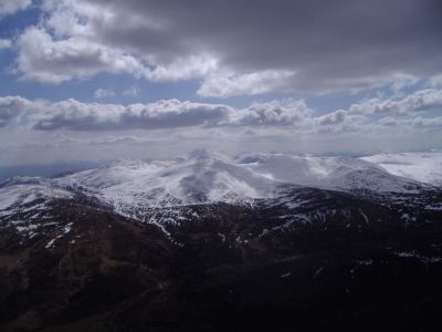
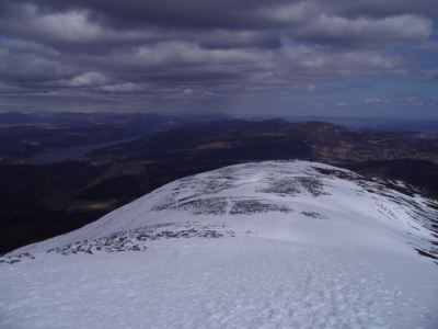
Views across Schiehallion's ridge back to Loch Tummel

I'll leave the route description and map to Walk Highlands, although provided you find the Braes of Foss car park, you can't really go wrong on this one! It's a single path up and back down, quite direct and not too bad all around. The only slight obstacle facing us was the prospect of some snow and ice. I wasn't really equiped for dealing with ice, so I went up with the intention of just going as far as I could manage. As it turns out the snow was fairly fresh and soft and really wasn't too hazardous at all, and was only really an issue for the last 500-600ft of the climb.

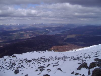
views North with the River Garry below

While Schiehallion is one of these slightly annoying mountains where you never get a good view of the summit, except from right at the start, you do absolutely stunning views back behind you to Loch Tummel, and better still South towards the Ben Lawers massif. Once you hit the top, Loch Rannoch also reveals itself, with the high peaks of the Cairngorms in the distance to the North (above), and those of Glen Coe in the West.

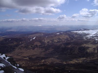
The Ben Lawers massif looking South from Schiehallion

Ben Lawers can be seen in the photo above, whereas Loch Tummel can be viewed below. I also did a quick KML, that should have the photo locations embedded. Or see a 360 degree movie from the summit!

Views across Loch Tummel
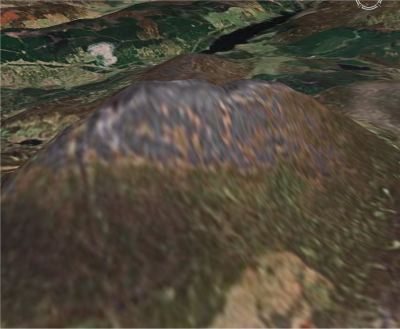
Below, roughly the view from Google Earth.

Views across Loch Tummel

Away from the photos, there is some prominent history behind Schiehallion. It was used by Nevil Maskelyne to calculate the mass of the earth, on the basis of knowing the mass of the mountain (it could be accurately calculated being such a conical shape) and the first mountain to be mapped using contour lines. General info on wikipedia and Munro Magic as ever. Better still, its name is used by a brewer for a rather tasty ale.

Labels: , , ,

Wednesday, 5 March 2008

A day at Glen Dollar - kml and photos

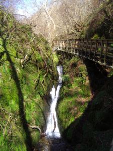
After a frantic week at work (major releases and major announcements (about which I can say nothing!)) - I decided to have a couple of hours to myself. As it was blowing a gale and in my rush to get away I had forgotten my hat, I opted to visit Glen Dollar. I've been meaning to walk around there for ages, but for whatever reason I've never taken the time too. It's a shame, as it's really quite accessible from Edinburgh, and after a day of rain (like when I went), it turns into an absolutely stunning little gorge, with waterfalls, lush vegetation and a majestic castle dominating the skyline.


Rather than post the pictures on here directly (bar the one above), I've compiled a little kml to show the location of the route and where a few of the photos were taken from.

Oh, a few weeks ago I went to seeEd Parsons give a presentation at the Edinburgh Earth Observatory series of seminars, at the Institute of Geography, Edinburgh. While it was an excellent presentation which I think the whole audience thoroughly enjoyed, he didn't really cover anything new, groundbreaking, or terribly exciting - hence why I haven't really bothered to blog about it 'till now. As the main focus was on Google Earth, I'm not really complaining - it was very enjoyable. Thanks for making the effort to come up Ed.

Labels: , ,

Wednesday, 16 January 2008

Virtual walking in Scotland

A few weeks ago I was pondering to myself why nobody had done anything clever yet in terms of getting many of Scotland's hill walking routes up on the web. There were plenty of amateur sites giving route descriptions and photos, or with snippets of OS maps included, or showing the rough location of the hill the walk focussed on - but none that went the whole hog.

For me the biggest bug bear is always figuring out from where a route starts, which is especially an issue if, like me, you are too tight to buy a walking guide, OS map etc. A motoring map or atlas just doesn't cut it when it comes to finding out where to park, what route to take etc.

OS mapping is now of course fairly freely available via OS's GetaMap, Multimap or various other mapping services - but it doesn't resolve the problem of where routes start, finish and roughly go on your now freely obtained OS printout.

Then Stefan at Ogle Earth posted about an email he received from the author, Paul Webster, of Walk Highlands - an online site of hill walking knowledge, with some great route descriptions (hundreds!), photos and for me, best of all, some awesome KML displaying these routes. I think it's a fantastic tool - my only qualm - I'm based in Edinburgh, and the areas he's left out for now are the ones nearest me! But not too worry!

The site is marvelously simple to navigate too, and packed full of information, from where to stay, what to do with your GPS device, what to make of the weather reports(!) and what else to see and do. There's a forum for general community stuff too. It's a little bit Isle of Skye focussed, but I'm sure it will expand if the demand is there. And if he manages to sell a few Amazon books out of it in the process (through the built-in Amazon shop/affiliate shceme), then fair enough for paying for the hosting costs.

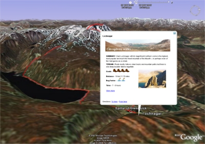
But for me, the best bit is the KML. Below is a sample of one of my favourite routes on Royal Deeside - Lochnagar - a route I've taken a few times myself (see route description and photos). The routes are coloured according to their grade, from easy to hard, there is the odd photo included plus a few other bits of information including a 'boggyness' scale.

kml lochnagar
Walkhighlands.co.uk KML sample

So no more excuses about not making it to the hills more often. This weekend I'm going. Honest!

Labels: , , ,

Saturday, 12 January 2008

Ski resorts in virtual globes and maps

Got ski fever today.. and since I can't afford or have time to jet off in search of snow, I thought I'd do some (web) surfing instead. Below, a bunch of links to some ski resources in Europe, mainly the Alps.

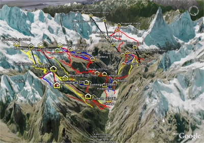
I started looking mainly at the KML out there. One of my favourites is one of the Swiss Alps resort of Zermatt posted by GE Earth Community member TommyAfrika. It shows the location of the various resorts around the region, many of the trails and pistes and best of all, it's in glorious high resolution imagery. Click the thumbnail below for a better view.


Then there's a great KML by SkiBumRick showing resorts in
the Tyrolean Alps. Not so many trails, but certainly a great list of resorts over in Austria.

Eastern Europe is catered for by KML's for both Slovakia and the Czech republic by GEC member maco.

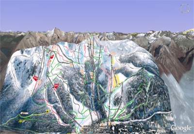
Further afield, in Argentina, Gerardo64 GEC member, has done a trail map overlay of the Cerro Catedral ski centre, Bariloche. It's a nice little KML of a part of the world I haven't done much exploring in. His post is also nicely annotated with photos of the resort, and winter fun!


In terms of a single KML for a huge list of resorts all over the globe, you could do worse than GEC member 1will's placemarks and links to snow reports. Not the most descriptive of placemarks, but there are an awful lot of them!

Finally, the GE blog has some interesting posts on mapping your ski trails in Google Earth using Geovisualiser. His KML is really interesting, and is colourised either by altitude or speed. So take your GPS with you next time you go skiing!


There is of course much more ski related KML out there, and this is just a selection from a few hours I've spent browsing. Sadly, quite a few of the older bigger KML's from a few years ago now have broken links and so have not been included. Couldn't find one for Scotland though..so maybe I should start work on that myself!

Labels: , , ,

Monday, 16 July 2007

Le Tour - Follow the Tour de France on the internet

With most of my day spent at uni finishing my dissertation, I've not been able to watch much Tour de France coverage on the TV. However, there are a great bunch of online tools by which you can follow every stage. It's a rest day today, so you won't be able to try these out until tomorow.

First up is the excellent Tour de France KML as posted recently on the Google Earth Blog. This allows you to view each of the tour stages in Google Earth - a real treat with the updated imagery for the Alps, allowing for an immersive 3D view of the alpine (and every other) stage. Frank Taylor (GE Blog) also posted a link to an excellent Google Maps Mashup showing the real time position of a variety of riders and team cars, as well as live information on riders heart-rate, power output and cadence.

In terms of actual race coverage, Eurosport has both the best live text and audio commentary. While the audio stream seems to suffer from over-subscription - at times it is completely unavailable - the live text updates and good graphics demonstrating the real time position of riders on the road and in relation to the stage elevation makes it a very useful tool. They also do live GPS tracking onto a map (a bit similiar to the google mashup, but not nearly as good).

Better yet is the Dutch National Broadcaster who are streaming their coverage of the tour over the internet. For a while the American broadcaster Versus was also streaming coverage, but it seems that they have been forced to close the stream for legal reasons (as reported on cyclingfans.com)

Finally, I haven't yet mentioned the official tour website LeTour.fr, in French, but which is also available in English, German and Spanish. Excellent coverage, in great detail, and full standings, stage overviews and anything else you could possibly want.

Hopefully this will make the internet experience of the cycling fan a bit easier. We still seem to be struggling a bit though - with English audio, tv pictures and commentary hard to come by. I apreciate this is due to the way 'internet' rights are marketed and sold, but it seems ridiculous that in 2007, there is only very limited choice in how we are able to watch the greatest race on earth. As far as I'm aware, nobody even offers pay per view coverage of the race. Any further suggestions, links and comments welcome.

Labels: , , ,

Saturday, 24 February 2007

Voronoi and end of week update

It's Saturday at last! A rather hectic week has past with this tricky paper on KML finally handed in. I attempted to cover coordinate transformations between different projections, and how KML might handle such an issue.

I managed to cover enough luckily without having to delve into some of the complex equations that you need to use. My main point, is that rather than have the client (GE etc.) interpret different notations of coordinate tags, which is probably unlikely, it may be possible to build these complex transformations into the XSLT that you would use to transform your XML data source into KML...?

Now I've just to do a small essay on using Virtual Worlds to aid teaching, a small exploratory data analysis exercise..and I'm finally done with courses and can focus on my dissertation.

Before heading out last night and consuming a few too many beers, I went to the Edinburgh Earth Observatory/AGI weekly seminar, which this week featured Chris Gold, EU Marie Curie chair at Glamorgan University and Voronoi Evangelist!. For such a potentially dry subject, focussing on algorithms, he made it remarkeably interesting, and is an excellent speaker. For those interested, Glamorgan University is hosting the Fourth Annual Symposium on Voronoi Diagrams

Finally, related to my dissertation, Earth is square links to an excellent article about using WW in the classroom.

Labels: , , ,

Tuesday, 20 February 2007

About Sedna & KML coordinate musings

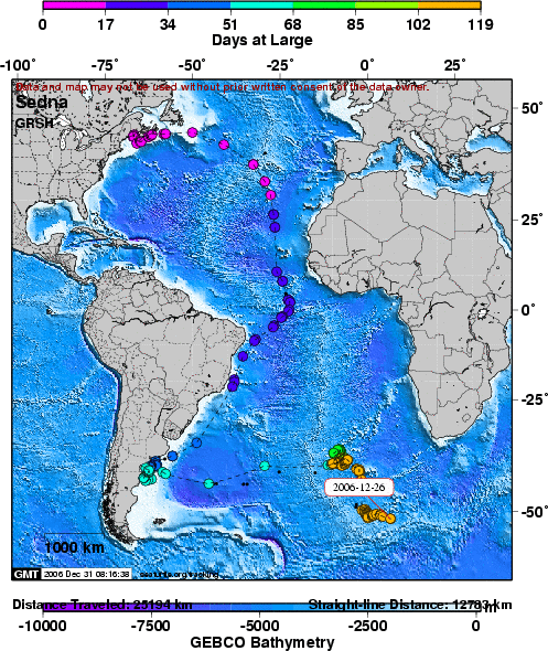
As I said in my previous post - there have been no further updates since boxing day on the shearwater whose progress I've been following. Knowing that GPS receivers don't transmit very well underwater, I had somehow just assumed that was the most likely cause - either by the device coming off, or a tragic event befalling our Sedna.

I emailed the team over at seaturtle.org and they had a far simpler, more obvious explaination.

There is a simple reason that you have stopped getting updates
on the shearwater tracks...batteries. Turtles are large and able to carry
transmitters with large batteries that will last a long time. Birds,
unfortunately, can only be tracked with short-lifespan tags due to weight
limitations. Sedna's battery was supposed to last only 90 days and we tracked
her for 118 days which we were very happy about!

Cheers, Rob


Good stuff!

sedna final map

Also for my geoinformatics essay I'm looking at a limitation within KML. Related to my dissertation on the Gazetteer for Scotland we are having a few issues converting from other map projections into what I assume to be GE projection datum (WGS84?). Wouldn't it be great if we could somehow auto-calculate/convert from say, British National Grid, straight into lat long coordinates. Sadly, it all doesn't seem quite as simple.. though the OS does a great booklet explaining some of the problems and limitations.

Finally, a great link I found to using virtual globes in the classroom.

Labels: , ,

Saturday, 17 February 2007

Jim Gray Search suspended. Interesting KML stuff..

According to All points blog, the official search for Jim Gray has been called off. In addition, the old link to the mechanical turk site no longer brings up the group.


Ogle Earth has a really interesting interview with Michael Jones, CTO at Google Earth, with some detailed information on searching and ranking KML files. Directions Mag also covers similiar ground. Worth a look for my KML essay due end of this week.

More soon.. gotta go out for dinner.

(edit)

Rather scary that I've appeared on Planet Geospatial! Better try to keep the quality up!

Labels:

Thursday, 11 January 2007

Bits and pieces + dissertation proposal

First of all - doing a course on geo-informatics and one of my coursemates pointed to an excellent flash movie explaining the many dimensions of our universe. It appears roughly adapted from the text we were prescribed by Abbott (1884).

Second, my dissertation proposal is due in fairly shortly, and I've decided to proceed along the lines of converting an online gazzeteer into XML data format, and provide some kind of interface and front ends for this data. This could be in the format of the older traditional website which could be 'cleaned' up, but perhaps more interestingly by providing mechanisms to some of the other means we have for disseminating information. Google Earth, and it's virtual globe peers, seem a good place to start, so one of the interesting projects would be to write some kind of XML to KML conversion.

On the blog front, several blogs reported and commented on the news of digital globe buying globe explorer. Which is interesting as the former is a major provider of data to google, while the other provides to Microsoft. Interesting..

Oh and the earth is square blog found this fantastic little terrain modelling, play gadget! brilliant!

Labels: , , , , , ,

Thursday, 21 December 2006

XML, KML and many mapping applications

Haven't blogged for a while since my exams finished. Taken a bit of a break from it, although I have been eagerly playing with google earth and worldwind.

Anyway, over the last few days, various sources have been blogging about mapping application being developed mainly for google earth.

But to begin with I just want to mention the Google Earth Blog top 25 GE stories from 2006 as a reference. It contains some fascinating posts on some of the best things happening in Google Earth. I've explored a few already, but with the long nights over Christmas I'm sure there will be time for more.

But anyway, back to mapping application. I'll start where I left off with the Google Earth Blog, whose author writes about a project that is using NOAA marine data to produce charts within google earth. Using KML regions he allows for changing levels of details in the data, including tidal changes. Pretty cool.

The Earth is Square blog, releases a sneak peek into some of the work on the ESA global fire atlas. With the release of the community developed MODIS historic plugin, he has now been able to release his own version, that updates daily on the state of global fires, as well as giving a historical record should it be required. This one is for WorldWind of course.

The final piece of news I wanted to chronicle is some work done by the GE community to go from google spreadsheets straight to kml, and to globe apps. It is reviewed by Ogle Earth, with the original post found here

Labels: , , , , ,

Monday, 27 November 2006

- visualising textual data
- making gazetteer co-ordinate data multi-platform (kml, gml?)

Labels: , ,