Sunday, 31 December 2006

Internet Radio

I listen to a lot of internet radio, primarily a dutch channel called 538. But I'd really like to be able to stream this to a receiver in another room, be it the kitchen when I'm cooking, or the lounge to relax. In addition it would be nice if I could stream the now vast collection of media I have stored on my pc directly to another room. There aren't that many options available at present, but I'll list below all the ones I have found so far:

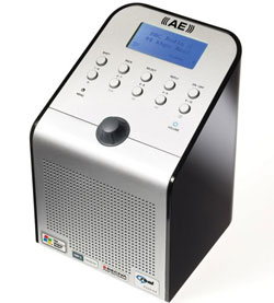
First up, the Wifi Internet Radio, by Acoustic Energy. It's retailing around the £160-170 mark, offering streaming in a range of formats (Real Media, MP3, WMA & AAC). It provides the ability to connect to open and WEP encrypted wireless networks, independant of a PC.
Available from: Overclockers,Superfi,Amazon,Dabs £148 ex del

Next up is the BT offering, the BT Internet Radio retailing around the £150 mark. Again, it claims to handle WEP and WPA encryption, and supports Real Audio, and media player formats (Real audio, WMA, MP3, AAC, AIFF & WAV). Cheapest place to buy I can find is direct from BT, so use the link above.

Then we have The Imp retailing around £150. It supports Real Audio, Windows Media, Mp3 and AAC, and WEP security (Not sure about WPA). There is also a related product which plugs into your home audio system, enabling you to stream internet and audio wirelessly to these devices (£99).

There are also offerings from a few other makes, though they do not seem as popular.
For instance:
- Logik IR100 - bit ugly looking but priced around £100
- Squeezebox Wireless Network Music Player - Very cool, but pricy (£210)
- Bush Internet Radio - around £120 from Argos.

Labels: ,

Thursday, 28 December 2006

Merry Christmas

Not doing much over Christmas. My parents broadband was being awkward until the BT engineer left without solving the problem - and the router amazingly reconnected ! I think I'd best not go into what I think about BT(again).

But anyway,

Cool GE app


Sydney to Hobart Yacht race near real-time positions and status from the yachts viewable in Google Earth. It's a KML file. As the GE blog notes, there seem to be some reliability issues with the link. Probably too much traffic caused by it being blogged across the globe.

WW problems


Tried to run the latest WW 1.0.4 RC2 from my dads laptop - but it wasnt having any of it. I suspect it's something to do with the .net implementation, and some older versions of XP possibly? Haven't tried it on my own machine yet...

Dissertation


I'm still not entirely sure where the dissertation is heading, but perhaps by blogging about it, I'll get ideas. I still reckon converting the raw data into XML, and then providing a range of front-ends is both a useful enough tool, and also a potentially good topic. I'll have to work hard to prove that virtual globes are a worthy endeavour for one of the front-end flavours.. but looking at some of the work that has already been done by some of the GE and WW writers within education, I think it's an interesting enough idea. I also read about a UK globes workshop, but can't for the life of me find the link back!! Some kind of environmental studies centre down in Cambridge? EDIT - Found it over at the excellent Ogle Earth

Labels: , ,

Thursday, 21 December 2006

XML, KML and many mapping applications

Haven't blogged for a while since my exams finished. Taken a bit of a break from it, although I have been eagerly playing with google earth and worldwind.

Anyway, over the last few days, various sources have been blogging about mapping application being developed mainly for google earth.

But to begin with I just want to mention the Google Earth Blog top 25 GE stories from 2006 as a reference. It contains some fascinating posts on some of the best things happening in Google Earth. I've explored a few already, but with the long nights over Christmas I'm sure there will be time for more.

But anyway, back to mapping application. I'll start where I left off with the Google Earth Blog, whose author writes about a project that is using NOAA marine data to produce charts within google earth. Using KML regions he allows for changing levels of details in the data, including tidal changes. Pretty cool.

The Earth is Square blog, releases a sneak peek into some of the work on the ESA global fire atlas. With the release of the community developed MODIS historic plugin, he has now been able to release his own version, that updates daily on the state of global fires, as well as giving a historical record should it be required. This one is for WorldWind of course.

The final piece of news I wanted to chronicle is some work done by the GE community to go from google spreadsheets straight to kml, and to globe apps. It is reviewed by Ogle Earth, with the original post found here

Labels: , , , , ,

Saturday, 16 December 2006

Google, NASA and the world

There is a certain amount of excitement floating around the virtual globe blogosphere about the forthcoming news that google and NASA are working together on a project called iEarth.

These rumours stem from an article published in New Scientist that explains the data overload problems NASA is having, and how throwing them out in the public domain, and making them readily accessible on the popular google earth, may solve these problems. Of course NASA has already been doing this to a certain extent as highlighted by a recent posting in the Google Earth Blog, but this seems to be the first time there will be widespread collaboration.

Possible data source for me to use, though it may come onstream a little late to use officially.

Labels: , ,

Wednesday, 13 December 2006

The animals unveiled!

Following extensive(!) public participation from a community of animal lovers, it was decided that migratory birds were, the uh, best. Of course they are biased in favour of birds (it is a bird community after all), so I've decided to track both a greater Shearwater called Sedna and a cool baby loggerhead turtle called Zahara.

Zahara, our turtle, according to seaturtle.org: ... was discovered nesting during the early morning hours of 20 August 2006. She measured 97.0cm in curved carapace length and was released with her satellite tag on 20 August 2006.(source)

zahara map courtesy of seaturtle.org

Image courtesy of SeaTurtle.org


She was discovered and released on Masirah Island, Oman on her birthday, and by my reckoning is approaching 4 months of age. After birth she moved slowly southwards along the Arabian peninsula just offshore. Then after moving briefly closer to shore during the middle-end of September, she has started to slowly spiral her way back out to deeper waters. She is currently some 100km offshore from the border of Oman/Yemen.

Sedna, our shearwater made her way from the upper reaches of NE United States during September down to their winter feeding grounds in the Southern hemisphere. After a month or so recuperation off the coast of Southern Argentina, she has now moved to the centre of the Southern Atlantic Ocean somewhere near the British islands of Inaccessible and Nightingale, having travelled almost 22500km's!

Hopefully this blog will keep track of both over the coming period - but for now, I must get back to my revision! The joys of the electromagnetic spectrum!

(edit - seaturtle.org kindly gave me permission to use a few graphics)

Labels: , , ,

Sunday, 3 December 2006

Tracking animals in google earth..

Very Spatial links to a few sites that use satellites to track animals. Nothing new perhaps, but in the case of the loggerhead turtle, they are now using googlemaps to track these creatures potentially offering a wealth of interesting information to would be adopters. Another interesting site WhaleNet has a list of marine animals it keeps track off using satellite beacons. Most of this data isn't rendered 'live', but they certainly have interesting maps and other data.

It makes me wonder - we've been doing this for a long time, and there must be a whole host of data available. I think a lot of people would be seriously interested in tracking specific species or individual animals within google maps. It perhaps poses a bit of a moral question of using wild animals for 'recreation', but besides the obvious attachment of a sensor (which it can be argued is firstly for scientific purposes) , there is little impact on the creature's life.

I might choose an animal for this blog ..and we'll keep track of it. More soon.

Labels: , , ,

Friday, 1 December 2006

Uses of RFID and future GIS?

All Points talks about a really interesting article, on the possible use of VR and GIS. It comes from research done at West Virginia University into Virtual Reality Geographic Information Systems. It has a host of uses on multiple platforms, including mobile. The most interesting is the FLEX system however, that immerses the user in a completely artificial 3d environment. The entire world can be navigated, flown over, and points of interest tagged. Read more.

SlashGeo talks about Sydney Airports decision to use RFID chips in their baggage handling system. Currently an awful lot of money is wasted by the industry dealing with lost baggage, due mainly to barcoding errors and faults. The Sydney Morning Herald reports that the introduction of these chips could reduce substantially the number of bags lost.

In related news, the highly publicised decision for Apple and Nike to release sportswear with embedded RFID chips, so that you can access certain information over your ipod (i.e. speed, distance, calories lost), has run into some trouble with news that these signals can easily be picked up by other devices.

Annalee Newitz writes:
Additionally, the sensor will reveal its unique ID to any Nike+ iPod receiver. With a quick hardware hack that Kohno said "any high school student could do in the garage," the researchers hooked a Nike+ iPod receiver up to a Linux-based "gumstix" -- a tiny, $79 computer that could easily be hidden in door frames, in trees next to jogging trails or in a pocket.
Source: wired.com

Labels: , , , , ,