Kilimanjaro - books and some background links
A couple of weeks ago, it was my birthday and while not feeling like death to the man flu/cold, I got given some Kilimanjaro books by my parents. My collection now includes two trekkers guides, a general travel guide and a booklet on altitude sickness. Brief reviews below.

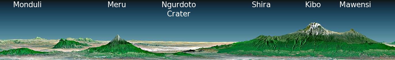
Source: Wikipedia
First up is the 'pocket' guide Kilimanjaro: The Trekking Guide to Africa's Highest Mountain - 2nd Edition (Trailblazer Guides) by Henry Stedman. It's a very well presented little book, with a good little general background about the area (having not been there yet, you'll forgive me for not knowing for sure!). It's much more a book tailored to precisely what I plan to do, trek Kilimanjaro, but also have my first experience of Africa, the area surrounding the mountain, choose an operator, consider all my options and so forth. It it's black and white, bar a few colour inserts (which are excellent). It includes the obligatory route descriptions with route sketches. I'm not sure yet whether I love or hate these! The best way to describe it really is as a Rough Guide or Lonely Planet, but one that goes into far greater detail on this specific area.
The other trekking guide I received, pitches itself a little differently from Stedman's. Kilimanjaro: Preparation, Practicalities and Ascent Routes (Cicerone Mountain Walking) by Alexander Stewart aims itself a little more closely at the trekking itself - though of course does also cover all the angles as the guide above, but just not in as much detail. Cicerone have a good reputation for trekking and climbing guides, and I must say, this book being colour throughout defintely has a better pick up and read appeal than the one by Stedman above. It extensively covers the flora and fauna, the ascent and descent routes as well as the mountaineering history behind the summit. I prefer it currently - though the jury is still out on which is best.
My final gift was a little book called Altitude Illness: Prevention and Treatment (Mountaineers Outdoor Expert) by Stephen Bezrucka. I'm sure this was inspired by a caring mother! To be honest, I haven't had much of a chance to read this yet, either to inform myself or stifle my enthusiasm. In any case, I'm sure it will be an important read.
The last book - not a gift - is the ever-excellent Rough Guide to Tanzania - Edition 2 . I'm fairly sure this doesn't need much of a review. Rough Guides are always packed full of information, usually fairly reliable. You either love these guides, or you're a lonely planet convert - there's rarely a middle ground! I like it, in particular for it's frank, honest and sometimes off-putting commentary on travel around the globe. If something is wrong with a place, the guide will usually say so.
More general reading of course on the web, though it's hard finding non-biased descriptions out amongst the hundreds of tour operator run websites. The UNEP page on Kilimanjaro National Park, has a nice if slightly statistically based description with plenty of further reading. The park website itself, though rather understated, has some nice photographs. While on about official websites, I found the Kilimanjaro Airport website particularly enthralling. Not sure about the akwardly resized Google image - but what it lacks in quality it makes up for in character! Then a live webcam encountered on a travel company page - though currently down - looks pretty cool. Will that do you for now?
Source: Wikipedia
First up is the 'pocket' guide Kilimanjaro: The Trekking Guide to Africa's Highest Mountain - 2nd Edition (Trailblazer Guides)
The other trekking guide I received, pitches itself a little differently from Stedman's. Kilimanjaro: Preparation, Practicalities and Ascent Routes (Cicerone Mountain Walking)
My final gift was a little book called Altitude Illness: Prevention and Treatment (Mountaineers Outdoor Expert)
The last book - not a gift - is the ever-excellent Rough Guide to Tanzania - Edition 2
More general reading of course on the web, though it's hard finding non-biased descriptions out amongst the hundreds of tour operator run websites. The UNEP page on Kilimanjaro National Park, has a nice if slightly statistically based description with plenty of further reading. The park website itself, though rather understated, has some nice photographs. While on about official websites, I found the Kilimanjaro Airport website particularly enthralling. Not sure about the akwardly resized Google image - but what it lacks in quality it makes up for in character! Then a live webcam encountered on a travel company page - though currently down - looks pretty cool. Will that do you for now?
Labels: kilimanjaro
posted by Jan at
21:02
0 Comments
Links to this post
![]()


