Tuesday, 5 February 2008

Tackling Kilimanjaro.. it begins here..
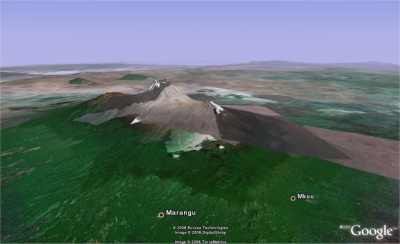
It was decided during this long and cold month that next year my dad and I will be making an attempt on Kilimanjaro, Africa's highest mountain and (apparently) the world's highest free standing mountain. I've already managed to collect a number of trekking brochures and guide books on Tanzania and the Kilimanjaro mountain, but what better way than to begin exploring it in a virtual globe?

Kilimanjaro in Google Earth
Looking over Kilimanjaro to the Serengeti plain in Google Earth.
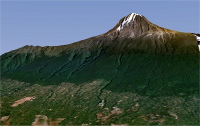
Looking up Kilimanjaro over the Machame trail in NASA's World Wind

Over the next year I'll hopefully be blogging about my preparations for this 'trek-of-a-lifetime' and I'd really apreciate if readers who have been there before left me comments and suggestions on what (and not) to do. I'll compile resources, hopefully plenty of Kili related KML and other Google Earth, Worldwind and other GIS'y related news items. And I'll try my best to take a GPS unit everywhere I go between now on my training preparations to the final step back off the mountain after our achievements (fingers crossed).

Also a quick mention to the Google Earth Blog who gave me my first bit of 'mainstream' blog publicity through the middle of January. Thanks Frank.

Labels: , , ,

Thursday, 10 May 2007

Google Earth Sounds + World Wind Fly thru demo

Haven't blogged for ages - sorry! Been very busy with work and endless PERL to do with my dissertation. Should have some stuff to show off with that in the next few weeks.. but in the meantime, I came across a cool news story, and a very nice JAVA world wind demo.

First up is the New Scientist story about a company called wild sanctuary who are working on software to embed these sound files into the relevant locations in Google Earth. The man behind it all, Bernie Krause, has got over 3500 hours of sound recordings from all over the world, taken over 40 years.

Krause plans to have the software ready with 26 sounds for demonstration at the Where 2.0 conference in San Jose, California, on 29 May.

The obvious question is whether users would be able to add their own sounds, and apparently work is underway on a project called Freesound. In any case, fantastic use of sound to create an immersive website, where so many have failed in the past (remember the dreadfull embedded Midi files?).

Next up the New Look The Earth is Square has links and screenshots for a World Wind JAVA demo, created by a company called DiSTI. I've been frustrated all day at uni trying to get it to work, and although I can get the fighter jet to appear, I don't get any of the landscapes. Not sure what the problem is (I presume port blocking), but now that I'm home, I've really enjoyed flying over real life locations (even if they are limited to a choice of around 5 or 6 at present). So nip over to Earth is Square for a preview, or jump straight in through this link.

Labels: ,

Saturday, 3 February 2007

News roundup: Scientist missing at sea

The major story is that last week Jim Gray, a prominent computer scientist at Microsoft went missing off the coast of San Fransisco. The coastguard called off the search, but the efforts continue through volunteers manually scanning satellite imagery in the search for his yacht. It's pretty difficult stuff, with the images not ortho-rectified and often pretty dirty/noisey - but the hope is that with lots of volunteers scouring billions of pixels, Jim's yacht may well be found.

The Earth is square also reports that the World Wind JAVA alpha release is looking for testers - preferably people with java development experience.

Labels: ,

Tuesday, 23 January 2007

Google and Microsoft take to the skies for Australia Day

The Earth is square blog highlights an interesting google maps implementation. I suppose I never really thought about the fact that your data source need not be maps, or aerial imagery, but could be anything really.. This one: Google World Domination!

Also from this very interesting blog, was a write-up of his experiences at the Digital Globe Conference. He has posted the presentation he used, and might be an interesting contact when it comes to considering my GE/WW/whatever else remake of the Gaz data.

The other interesting piece of information I found on the GE Blog was some competition between Microsoft and Google during Australia Day 2007. Having been in Sydney for Australia day last year.. it's pretty cool that both these big companies are using this as a publicity stunt, that should create some great imagery. As reported by the Sydney Morning Herald The Microsoft Virtual Earth blog also reports that they have created a special map showing Australia Day events right across Australia.

-EDIT - There was a huge Virtual Earth update a few days ago, covering some fantastic European Cities. You'll need to install the plugin though.

Labels: , , ,

Thursday, 28 December 2006

Merry Christmas

Not doing much over Christmas. My parents broadband was being awkward until the BT engineer left without solving the problem - and the router amazingly reconnected ! I think I'd best not go into what I think about BT(again).

But anyway,

Cool GE app


Sydney to Hobart Yacht race near real-time positions and status from the yachts viewable in Google Earth. It's a KML file. As the GE blog notes, there seem to be some reliability issues with the link. Probably too much traffic caused by it being blogged across the globe.

WW problems


Tried to run the latest WW 1.0.4 RC2 from my dads laptop - but it wasnt having any of it. I suspect it's something to do with the .net implementation, and some older versions of XP possibly? Haven't tried it on my own machine yet...

Dissertation


I'm still not entirely sure where the dissertation is heading, but perhaps by blogging about it, I'll get ideas. I still reckon converting the raw data into XML, and then providing a range of front-ends is both a useful enough tool, and also a potentially good topic. I'll have to work hard to prove that virtual globes are a worthy endeavour for one of the front-end flavours.. but looking at some of the work that has already been done by some of the GE and WW writers within education, I think it's an interesting enough idea. I also read about a UK globes workshop, but can't for the life of me find the link back!! Some kind of environmental studies centre down in Cambridge? EDIT - Found it over at the excellent Ogle Earth

Labels: , ,

Thursday, 21 December 2006

XML, KML and many mapping applications

Haven't blogged for a while since my exams finished. Taken a bit of a break from it, although I have been eagerly playing with google earth and worldwind.

Anyway, over the last few days, various sources have been blogging about mapping application being developed mainly for google earth.

But to begin with I just want to mention the Google Earth Blog top 25 GE stories from 2006 as a reference. It contains some fascinating posts on some of the best things happening in Google Earth. I've explored a few already, but with the long nights over Christmas I'm sure there will be time for more.

But anyway, back to mapping application. I'll start where I left off with the Google Earth Blog, whose author writes about a project that is using NOAA marine data to produce charts within google earth. Using KML regions he allows for changing levels of details in the data, including tidal changes. Pretty cool.

The Earth is Square blog, releases a sneak peek into some of the work on the ESA global fire atlas. With the release of the community developed MODIS historic plugin, he has now been able to release his own version, that updates daily on the state of global fires, as well as giving a historical record should it be required. This one is for WorldWind of course.

The final piece of news I wanted to chronicle is some work done by the GE community to go from google spreadsheets straight to kml, and to globe apps. It is reviewed by Ogle Earth, with the original post found here

Labels: , , , , ,