Monday, 7 December 2009

We're moving!

OK - so I haven't blogged for, well, ages. The last year has been unbelievably busy and frantic. However I've rather missed blogging about this and that, so I've decided to resurrect this blog for at least a few months and see how things go.

First of all, I'm changing the slant of the blog slightly. It will still focus on much of what it did before. However the focus in particular is going to move closer towards available online sources of mapping and map data - rather than a particularly wide range of GIS type stuff it covered before. While I may cover all sorts of digital cartography related things, I think in particular I am interested in those that are also available as web services for use in other applications.

As a secondary focus, I am now living in South Queensferry. I love it here, and things are about to get even more exciting. A new Forth Road bridge is planned for construction over the next decade or so. It will be interesting to see what kind of 'new media' coverage there will be of this project.

Finally, I am hoping to move across to the wordpress platform. It's something I've toyed with for a while, but I've never really had the time to take the plunge. Don't get me wrong, blogger has been great for blogging, but I hope the new site will be much more than a blog - a categorised list of online cartography, digital maps, web map services and examples of the best mashups that tie all of them together.

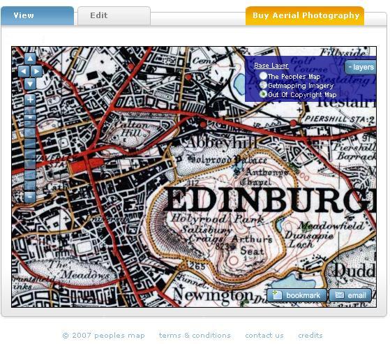
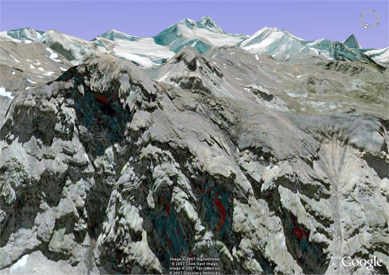
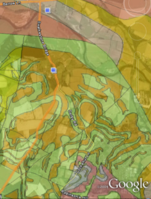
So just to ease everyone in, today I saw posted on BBC News that the British Geological Survey has launched a website allowing free access to their repository of geological maps. Not only are there website based viewers, this one built on ESRI software, there are also KML feeds for use in Google Earth and Maps and even a free (for non-commercial use) WMS. Although admittedly this has been down for most of the day, presumably under heavy traffic from the BBC posting. Finally, and this is nearly unheard of from a public body, the entire dataset can be downloaded as digital map files in shape or tab file format for use in your favourite GIS.

bgs screenshot
Of course, it's not all there yet - all of the detailed data down to 1:10k level is still only available under license and it won't surprise you that any off-shore data is not included. Still - I'd love to see this free data used in any examples.

Labels: , , , , ,

Monday, 31 March 2008

Collapse of the Wilkins ice shelf?

Usually 'scientific' stories like these fail to hit the headlines, unless accompanied by some wild doom and gloom headlines or miracle diet. The BBC however ran this story last week after capturing some video footage of the Wilkins Ice Shelf collapse. Further press reports by The Guardian, The Times and CNN brought the story into the mainstream, placing the blame firmly at the hands of global warming (who or what else?).


source: National Snow and Ice Data Center

Rather than just read-about it, a number of GE Community Members contributed to KML links showing imagery in Google Earth, some of them over time. My favourite KML though is the delightfully simple effort by NASA to compile four images showing the moment of the breakup, and the end result just over two weeks later. Samples below.


Of course, Ogle Earth had the best round-up, with some nice embedded videos and it's own KML file. For an overview of the different ice shelves and excellent links to imagery, you could do worse than the National Snow and Ice Data Center's compilation of it's Antarctic data sets. Plenty of images available there to import into a virtual globe there!

Labels: , , ,

Tuesday, 5 February 2008

Tackling Kilimanjaro.. it begins here..

It was decided during this long and cold month that next year my dad and I will be making an attempt on Kilimanjaro, Africa's highest mountain and (apparently) the world's highest free standing mountain. I've already managed to collect a number of trekking brochures and guide books on Tanzania and the Kilimanjaro mountain, but what better way than to begin exploring it in a virtual globe?

Kilimanjaro in Google Earth
Looking over Kilimanjaro to the Serengeti plain in Google Earth.

Looking up Kilimanjaro over the Machame trail in NASA's World Wind

Over the next year I'll hopefully be blogging about my preparations for this 'trek-of-a-lifetime' and I'd really apreciate if readers who have been there before left me comments and suggestions on what (and not) to do. I'll compile resources, hopefully plenty of Kili related KML and other Google Earth, Worldwind and other GIS'y related news items. And I'll try my best to take a GPS unit everywhere I go between now on my training preparations to the final step back off the mountain after our achievements (fingers crossed).

Also a quick mention to the Google Earth Blog who gave me my first bit of 'mainstream' blog publicity through the middle of January. Thanks Frank.

Labels: , , ,

Wednesday, 16 January 2008

Virtual walking in Scotland

A few weeks ago I was pondering to myself why nobody had done anything clever yet in terms of getting many of Scotland's hill walking routes up on the web. There were plenty of amateur sites giving route descriptions and photos, or with snippets of OS maps included, or showing the rough location of the hill the walk focussed on - but none that went the whole hog.

For me the biggest bug bear is always figuring out from where a route starts, which is especially an issue if, like me, you are too tight to buy a walking guide, OS map etc. A motoring map or atlas just doesn't cut it when it comes to finding out where to park, what route to take etc.

OS mapping is now of course fairly freely available via OS's GetaMap, Multimap or various other mapping services - but it doesn't resolve the problem of where routes start, finish and roughly go on your now freely obtained OS printout.

Then Stefan at Ogle Earth posted about an email he received from the author, Paul Webster, of Walk Highlands - an online site of hill walking knowledge, with some great route descriptions (hundreds!), photos and for me, best of all, some awesome KML displaying these routes. I think it's a fantastic tool - my only qualm - I'm based in Edinburgh, and the areas he's left out for now are the ones nearest me! But not too worry!

The site is marvelously simple to navigate too, and packed full of information, from where to stay, what to do with your GPS device, what to make of the weather reports(!) and what else to see and do. There's a forum for general community stuff too. It's a little bit Isle of Skye focussed, but I'm sure it will expand if the demand is there. And if he manages to sell a few Amazon books out of it in the process (through the built-in Amazon shop/affiliate shceme), then fair enough for paying for the hosting costs.

But for me, the best bit is the KML. Below is a sample of one of my favourite routes on Royal Deeside - Lochnagar - a route I've taken a few times myself (see route description and photos). The routes are coloured according to their grade, from easy to hard, there is the odd photo included plus a few other bits of information including a 'boggyness' scale.

kml lochnagar
Walkhighlands.co.uk KML sample

So no more excuses about not making it to the hills more often. This weekend I'm going. Honest!

Labels: , , ,

Saturday, 12 January 2008

Ski resorts in virtual globes and maps

Got ski fever today.. and since I can't afford or have time to jet off in search of snow, I thought I'd do some (web) surfing instead. Below, a bunch of links to some ski resources in Europe, mainly the Alps.

I started looking mainly at the KML out there. One of my favourites is one of the Swiss Alps resort of Zermatt posted by GE Earth Community member TommyAfrika. It shows the location of the various resorts around the region, many of the trails and pistes and best of all, it's in glorious high resolution imagery. Click the thumbnail below for a better view.


Then there's a great KML by SkiBumRick showing resorts in
the Tyrolean Alps. Not so many trails, but certainly a great list of resorts over in Austria.

Eastern Europe is catered for by KML's for both Slovakia and the Czech republic by GEC member maco.

Further afield, in Argentina, Gerardo64 GEC member, has done a trail map overlay of the Cerro Catedral ski centre, Bariloche. It's a nice little KML of a part of the world I haven't done much exploring in. His post is also nicely annotated with photos of the resort, and winter fun!


In terms of a single KML for a huge list of resorts all over the globe, you could do worse than GEC member 1will's placemarks and links to snow reports. Not the most descriptive of placemarks, but there are an awful lot of them!

Finally, the GE blog has some interesting posts on mapping your ski trails in Google Earth using Geovisualiser. His KML is really interesting, and is colourised either by altitude or speed. So take your GPS with you next time you go skiing!


There is of course much more ski related KML out there, and this is just a selection from a few hours I've spent browsing. Sadly, quite a few of the older bigger KML's from a few years ago now have broken links and so have not been included. Couldn't find one for Scotland though..so maybe I should start work on that myself!

Labels: , , ,

Monday, 16 July 2007

Le Tour - Follow the Tour de France on the internet

With most of my day spent at uni finishing my dissertation, I've not been able to watch much Tour de France coverage on the TV. However, there are a great bunch of online tools by which you can follow every stage. It's a rest day today, so you won't be able to try these out until tomorow.

First up is the excellent Tour de France KML as posted recently on the Google Earth Blog. This allows you to view each of the tour stages in Google Earth - a real treat with the updated imagery for the Alps, allowing for an immersive 3D view of the alpine (and every other) stage. Frank Taylor (GE Blog) also posted a link to an excellent Google Maps Mashup showing the real time position of a variety of riders and team cars, as well as live information on riders heart-rate, power output and cadence.

In terms of actual race coverage, Eurosport has both the best live text and audio commentary. While the audio stream seems to suffer from over-subscription - at times it is completely unavailable - the live text updates and good graphics demonstrating the real time position of riders on the road and in relation to the stage elevation makes it a very useful tool. They also do live GPS tracking onto a map (a bit similiar to the google mashup, but not nearly as good).

Better yet is the Dutch National Broadcaster who are streaming their coverage of the tour over the internet. For a while the American broadcaster Versus was also streaming coverage, but it seems that they have been forced to close the stream for legal reasons (as reported on cyclingfans.com)

Finally, I haven't yet mentioned the official tour website LeTour.fr, in French, but which is also available in English, German and Spanish. Excellent coverage, in great detail, and full standings, stage overviews and anything else you could possibly want.

Hopefully this will make the internet experience of the cycling fan a bit easier. We still seem to be struggling a bit though - with English audio, tv pictures and commentary hard to come by. I apreciate this is due to the way 'internet' rights are marketed and sold, but it seems ridiculous that in 2007, there is only very limited choice in how we are able to watch the greatest race on earth. As far as I'm aware, nobody even offers pay per view coverage of the race. Any further suggestions, links and comments welcome.

Labels: , , ,

Thursday, 24 May 2007

People's map BETA & new Yahoo maps

From an email I received last night, it looks like The XYZ Digital Map Company, a business based up here just outside Edinburgh, have made a new service available called People's Map.

OS map 1920


While it looks and feels much like all the other google maps clones, it allows you not only to access the "people's map", a nicely designed map product - but also to access other layers such as the out of copyright 1920's Ordance Survey Map or high resolution getmapping imagery of the entire United Kingdom. Tbe photo below shows the harbour at Portree on the Isle of Skye for instance.

And why is it called People's Map? Well presumeably because XYZ plan to allow people to be able to edit and correct the maps themselves (a bit like wikipedia). Currently this mode isn't available yet, though they allow you to register on the page and be informed when this feature does become available. You can also buy aerial photography of your selected region (via getmapping).

Portree Harbour, Skye

For those wishing to use it as part of their websites, it is possible to pass parameters in the URL. The man behind it all, Tim Rideout, is presenting at the GISupdate conference here at the University next week, so I'm sure I'll hear more about it then.

I wanted to cover the rumour and news of Google buying up all of the SPOT imagery, but can't find anything official on it. Or more substantive. Or I'm not looking hard enough.

Instead, news of Yahoo Maps' fresh new look. Most of the changes are covered on the blog , but it struck me that suddenly the interface feels much cleaner, crisper and ultimately more useable. Glad Google is getting decent competition. Aerial imagery for a lot of Europe is terrible though!

Labels: , ,

Thursday, 10 May 2007

Google Earth Sounds + World Wind Fly thru demo

Haven't blogged for ages - sorry! Been very busy with work and endless PERL to do with my dissertation. Should have some stuff to show off with that in the next few weeks.. but in the meantime, I came across a cool news story, and a very nice JAVA world wind demo.

First up is the New Scientist story about a company called wild sanctuary who are working on software to embed these sound files into the relevant locations in Google Earth. The man behind it all, Bernie Krause, has got over 3500 hours of sound recordings from all over the world, taken over 40 years.

Krause plans to have the software ready with 26 sounds for demonstration at the Where 2.0 conference in San Jose, California, on 29 May.

The obvious question is whether users would be able to add their own sounds, and apparently work is underway on a project called Freesound. In any case, fantastic use of sound to create an immersive website, where so many have failed in the past (remember the dreadfull embedded Midi files?).

Next up the New Look The Earth is Square has links and screenshots for a World Wind JAVA demo, created by a company called DiSTI. I've been frustrated all day at uni trying to get it to work, and although I can get the fighter jet to appear, I don't get any of the landscapes. Not sure what the problem is (I presume port blocking), but now that I'm home, I've really enjoyed flying over real life locations (even if they are limited to a choice of around 5 or 6 at present). So nip over to Earth is Square for a preview, or jump straight in through this link.

Labels: ,

Thursday, 15 March 2007

Viewshed calculations HeyWhatsThat, Dull and XML editors

Ogle Earth finds another gem in the form of HeyWhatsThat.com, which uses the SRTM data that is available with GE, to perform viewshed calculations. It can output directly to Google Maps, where it draws a 360 degree panorama that interacts with the google map interface. It also identifies the peaks visible from your position, and you can highlight the entire viewshed in red.

You can also import the entire set into Google Earth, to, I suppose test if the algorithm is correct. Very very cool.

Another useful thing I saw related to education, was a post on slashgeo.org concerning the use of Skype to control virtual globes on another computer. Unype allows two (or more?) users to interact with each others globe, showing them around, and so on. GE Blog reviews and also has a video.

But anyway, after having criticised the Gazetteer for Scotland in an earlier post, I suppose I had better make amends! I was of course referring to the village of Dull in Perth and Kinross. *cough*

I did some work getting XLST to work today, with limited success. I did after hacking up a quick XML sample of one of the Gazetteers pages, manage to reproduce a html document with some images from that XML source using XLST. The plan is to produce some samples for use in my presentation on Monday, perhaps an html document with two seperate stylesheets, and maybe KML, to demonstrate how powerful XSLT can be.

The only major problem I've had is in my search for a good editor. I decided to start off simple with Microsoft's XML Notepad 2007 . At first glance it did exactly what I wanted it for, but it has some really annoying bugs, especially that you need to close and re-open the XSLT stylesheet everytime you want to re-transform (the copy must be cached inside). So that was useless.

I then tried Oxygen. This was complete at the other end of the scale. Not only do I just get a 30 day trial, but it's also so incredibly complex with so much functionality that I really don't need. Having said that, it worked quite nicely if you ignore _all_ the functions and just use it as an editor, and as a tool for running the XSLT.

Anyone have better suggestions?

Labels: , , , , ,

Sunday, 11 March 2007

Google Lit Trips, Meteox, and the beautiful Alps

Just as was trying to explain how virtual globes can lead narratives, Ogle Earth links to GoogleLitTrips.org, a really nice example of how we can use visualisations to aid within wider education, in this case renowned literary works.

Then my dad pointed me towards meteox.co.uk which despite the URL seems to be a Dutch site that uses both google and geodan maps to display rainfall (radar) across europe. It also does the (now) obligatory Google Earth KMZ link for all the data, though while it updates hourly, it doesn't allow for time-led animations in the same way the maps do.

meteox screenshot

Finally, I never wrote about it, but various sources reported the huge update to Google Earth and especially the Swiss Alps. Some of the new imagery draped over the elevation data reproduces some of the stunning scenery. Now, just to have the time and the money to head in search of the snow!

alps

While I was exploring, anyone know what kind of rock turned up red and blue on the imagery though?

red rocks

Oh and some final quick links for reference:
- Ogle Earth and KML editors
- Earth is square on MapleCroft Maps

Labels: , , ,

Thursday, 25 January 2007

Geovisualisation essay

A post in the GE blog on some Second Life and Virtual World stuff..

Also CBBC World

Labels: ,

hi-tech cattle branding

Via slashgeo is the story of hi-tec cattle branding. While traditionally we have microchipped pets, and some animals, it has proved to expensive to embed these in cattle, instead them being tagged in the ear - which has some negative sides. This is promising a RFID tattoo by which cattle could be identified.

The All Points Blog runs an article on the semantic web and possible implementations for Google new patent. As the blog states.. it looks like the development of real semantic networks could be more of a money/business issue than for academic good.

The Google Earth Blog reports on KLM releasing a GE network link as a means of promoting it's products. As initially reported in Emerce.nl. It also reveals the real world google earth development business behind this KLM release.

Finally, some of the things we're doing in GEOVIS.. Ogle Earth has a great video about Perceptive Pixel.

Labels: , , ,

Thursday, 28 December 2006

Merry Christmas

Not doing much over Christmas. My parents broadband was being awkward until the BT engineer left without solving the problem - and the router amazingly reconnected ! I think I'd best not go into what I think about BT(again).

But anyway,

Cool GE app


Sydney to Hobart Yacht race near real-time positions and status from the yachts viewable in Google Earth. It's a KML file. As the GE blog notes, there seem to be some reliability issues with the link. Probably too much traffic caused by it being blogged across the globe.

WW problems


Tried to run the latest WW 1.0.4 RC2 from my dads laptop - but it wasnt having any of it. I suspect it's something to do with the .net implementation, and some older versions of XP possibly? Haven't tried it on my own machine yet...

Dissertation


I'm still not entirely sure where the dissertation is heading, but perhaps by blogging about it, I'll get ideas. I still reckon converting the raw data into XML, and then providing a range of front-ends is both a useful enough tool, and also a potentially good topic. I'll have to work hard to prove that virtual globes are a worthy endeavour for one of the front-end flavours.. but looking at some of the work that has already been done by some of the GE and WW writers within education, I think it's an interesting enough idea. I also read about a UK globes workshop, but can't for the life of me find the link back!! Some kind of environmental studies centre down in Cambridge? EDIT - Found it over at the excellent Ogle Earth

Labels: , ,

Thursday, 21 December 2006

XML, KML and many mapping applications

Haven't blogged for a while since my exams finished. Taken a bit of a break from it, although I have been eagerly playing with google earth and worldwind.

Anyway, over the last few days, various sources have been blogging about mapping application being developed mainly for google earth.

But to begin with I just want to mention the Google Earth Blog top 25 GE stories from 2006 as a reference. It contains some fascinating posts on some of the best things happening in Google Earth. I've explored a few already, but with the long nights over Christmas I'm sure there will be time for more.

But anyway, back to mapping application. I'll start where I left off with the Google Earth Blog, whose author writes about a project that is using NOAA marine data to produce charts within google earth. Using KML regions he allows for changing levels of details in the data, including tidal changes. Pretty cool.

The Earth is Square blog, releases a sneak peek into some of the work on the ESA global fire atlas. With the release of the community developed MODIS historic plugin, he has now been able to release his own version, that updates daily on the state of global fires, as well as giving a historical record should it be required. This one is for WorldWind of course.

The final piece of news I wanted to chronicle is some work done by the GE community to go from google spreadsheets straight to kml, and to globe apps. It is reviewed by Ogle Earth, with the original post found here

Labels: , , , , ,

Saturday, 16 December 2006

Google, NASA and the world

There is a certain amount of excitement floating around the virtual globe blogosphere about the forthcoming news that google and NASA are working together on a project called iEarth.

These rumours stem from an article published in New Scientist that explains the data overload problems NASA is having, and how throwing them out in the public domain, and making them readily accessible on the popular google earth, may solve these problems. Of course NASA has already been doing this to a certain extent as highlighted by a recent posting in the Google Earth Blog, but this seems to be the first time there will be widespread collaboration.

Possible data source for me to use, though it may come onstream a little late to use officially.

Labels: , ,

Tuesday, 28 November 2006

3d space pheripherals

One of the things that has been lacking in the terrestrial, non-CAD world, has been the viable alternative to the mouse. Yes, there are trackerballs and other pointers, but on the whole we have been restricted to the commodity item of the mouse. Even if we do have very good accurate optical ones these days. While a few consoles have just been released that use motion sensors (the Wii) in their controllers.. we've still really been waiting for something for the humble PC.

Well, the wait is over. Ogle Earth reviews the SpaceNavigator by 3Dconnexion, a subsidiary of Logitech. It also includes some interesting uses within Google Earth. And the good thing is, that at US$60, they are relatively affordable. With the SDK coming soon, there will hopefully be a whole range of applications, and possibly OS interactions. I wonder if the gaming market will embrace these?

Labels: , , ,