We're moving!
OK - so I haven't blogged for, well, ages. The last year has been unbelievably busy and frantic. However I've rather missed blogging about this and that, so I've decided to resurrect this blog for at least a few months and see how things go.
First of all, I'm changing the slant of the blog slightly. It will still focus on much of what it did before. However the focus in particular is going to move closer towards available online sources of mapping and map data - rather than a particularly wide range of GIS type stuff it covered before. While I may cover all sorts of digital cartography related things, I think in particular I am interested in those that are also available as web services for use in other applications.
As a secondary focus, I am now living in South Queensferry. I love it here, and things are about to get even more exciting. A new Forth Road bridge is planned for construction over the next decade or so. It will be interesting to see what kind of 'new media' coverage there will be of this project.
Finally, I am hoping to move across to the wordpress platform. It's something I've toyed with for a while, but I've never really had the time to take the plunge. Don't get me wrong, blogger has been great for blogging, but I hope the new site will be much more than a blog - a categorised list of online cartography, digital maps, web map services and examples of the best mashups that tie all of them together.
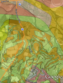
So just to ease everyone in, today I saw posted on BBC News that the British Geological Survey has launched a website allowing free access to their repository of geological maps. Not only are there website based viewers, this one built on ESRI software, there are also KML feeds for use in Google Earth and Maps and even a free (for non-commercial use) WMS. Although admittedly this has been down for most of the day, presumably under heavy traffic from the BBC posting. Finally, and this is nearly unheard of from a public body, the entire dataset can be downloaded as digital map files in shape or tab file format for use in your favourite GIS.

Of course, it's not all there yet - all of the detailed data down to 1:10k level is still only available under license and it won't surprise you that any off-shore data is not included. Still - I'd love to see this free data used in any examples.
First of all, I'm changing the slant of the blog slightly. It will still focus on much of what it did before. However the focus in particular is going to move closer towards available online sources of mapping and map data - rather than a particularly wide range of GIS type stuff it covered before. While I may cover all sorts of digital cartography related things, I think in particular I am interested in those that are also available as web services for use in other applications.
As a secondary focus, I am now living in South Queensferry. I love it here, and things are about to get even more exciting. A new Forth Road bridge is planned for construction over the next decade or so. It will be interesting to see what kind of 'new media' coverage there will be of this project.
Finally, I am hoping to move across to the wordpress platform. It's something I've toyed with for a while, but I've never really had the time to take the plunge. Don't get me wrong, blogger has been great for blogging, but I hope the new site will be much more than a blog - a categorised list of online cartography, digital maps, web map services and examples of the best mashups that tie all of them together.
So just to ease everyone in, today I saw posted on BBC News that the British Geological Survey has launched a website allowing free access to their repository of geological maps. Not only are there website based viewers, this one built on ESRI software, there are also KML feeds for use in Google Earth and Maps and even a free (for non-commercial use) WMS. Although admittedly this has been down for most of the day, presumably under heavy traffic from the BBC posting. Finally, and this is nearly unheard of from a public body, the entire dataset can be downloaded as digital map files in shape or tab file format for use in your favourite GIS.

Of course, it's not all there yet - all of the detailed data down to 1:10k level is still only available under license and it won't surprise you that any off-shore data is not included. Still - I'd love to see this free data used in any examples.


