Wednesday, 16 December 2009

Road traffic deaths map

Today, something a little morbid - but a fascinating look at the use of 'free' online mapping to display a really interesting dataset.

road traffic deaths
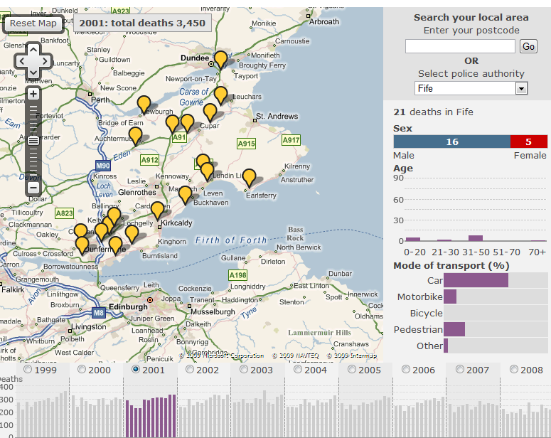
The BBC have compiled a Road Traffic Deaths map. This allows you to map incidents of all road traffic deaths in your police authority, or in the area you are viewing on the google map. Ten years worth of data is included, and some pretty accurate point locations have been set for each of the deaths, certainly from those incidents I can remember. There is even some detail about the parties involved including age, sex and the type of vehicle. This data is displayed for the police authority on a bar chart to allow exploration of the demographic.

Labels: ,

Monday, 16 July 2007

Le Tour - Follow the Tour de France on the internet

With most of my day spent at uni finishing my dissertation, I've not been able to watch much Tour de France coverage on the TV. However, there are a great bunch of online tools by which you can follow every stage. It's a rest day today, so you won't be able to try these out until tomorow.

First up is the excellent Tour de France KML as posted recently on the Google Earth Blog. This allows you to view each of the tour stages in Google Earth - a real treat with the updated imagery for the Alps, allowing for an immersive 3D view of the alpine (and every other) stage. Frank Taylor (GE Blog) also posted a link to an excellent Google Maps Mashup showing the real time position of a variety of riders and team cars, as well as live information on riders heart-rate, power output and cadence.

In terms of actual race coverage, Eurosport has both the best live text and audio commentary. While the audio stream seems to suffer from over-subscription - at times it is completely unavailable - the live text updates and good graphics demonstrating the real time position of riders on the road and in relation to the stage elevation makes it a very useful tool. They also do live GPS tracking onto a map (a bit similiar to the google mashup, but not nearly as good).

Better yet is the Dutch National Broadcaster who are streaming their coverage of the tour over the internet. For a while the American broadcaster Versus was also streaming coverage, but it seems that they have been forced to close the stream for legal reasons (as reported on cyclingfans.com)

Finally, I haven't yet mentioned the official tour website LeTour.fr, in French, but which is also available in English, German and Spanish. Excellent coverage, in great detail, and full standings, stage overviews and anything else you could possibly want.

Hopefully this will make the internet experience of the cycling fan a bit easier. We still seem to be struggling a bit though - with English audio, tv pictures and commentary hard to come by. I apreciate this is due to the way 'internet' rights are marketed and sold, but it seems ridiculous that in 2007, there is only very limited choice in how we are able to watch the greatest race on earth. As far as I'm aware, nobody even offers pay per view coverage of the race. Any further suggestions, links and comments welcome.

Labels: , , ,

Monday, 2 April 2007

April catch up - Glencoe, FutureTV and news.

I've been pretty busy over the past month or so - and I've just realised I haven't done any blogging. That doesn't mean I've ditched my course, or even been on holiday (much), just that the time has flown by!

So, a quick catch up. First, three fellow students are doing Gazetteer for Scotland topics, and we have a combined questionaire on the ScotGaz website to try and get some customer feedback. Some criticism of it too, as apparently I left no space to comment or suggest educational ideas. My fault, though I'll happily take suggestions here, in addition to the comments and emails ive already received.

As a class we had a brief three day holiday in Glencoe, Western Scotland. Had a really good time, with fantastic scenery and even a day on the slopes! I'll post more photos on my website in the near future.

river coe
River Coe, Glencoe.
ben nevis
Ben Nevis from Aonoch Mor

Anyway, back to some links related to my dissertation, and to start one that really isn't!

Firstly, Hey What's That.com that I blogged about before, has now made their viewshed analysis tool available to the rest of the World. Some of the data is a bit crumbly, and not nearly as accurate for most of Europe as it is in the U.S. but for some locations most noticeably The Alps and other hi-res areas around the world it works a treat. For instance, this is the view from West Lomond in Fife. Bit odd you can't see much east, because the other summit East Lomond, really isn't that imposing!

- Ogle Earth mentioned a really interesting project involving the visualisation of non-spatial data in Google Earth, and some similiar work involving Second Life. Worth a read.

- A bit off-topic but related to above, Microsoft Virtual Earth April Fool's Joke! but also a huge update (UK included) a few days previous. Cool.

Oh and I almost forgot, one of our lecturers, talks on UK Future TV.com about The Future of mapping in the digital age

Labels: , , ,

Thursday, 15 March 2007

Viewshed calculations HeyWhatsThat, Dull and XML editors

Ogle Earth finds another gem in the form of HeyWhatsThat.com, which uses the SRTM data that is available with GE, to perform viewshed calculations. It can output directly to Google Maps, where it draws a 360 degree panorama that interacts with the google map interface. It also identifies the peaks visible from your position, and you can highlight the entire viewshed in red.

You can also import the entire set into Google Earth, to, I suppose test if the algorithm is correct. Very very cool.

Another useful thing I saw related to education, was a post on slashgeo.org concerning the use of Skype to control virtual globes on another computer. Unype allows two (or more?) users to interact with each others globe, showing them around, and so on. GE Blog reviews and also has a video.

But anyway, after having criticised the Gazetteer for Scotland in an earlier post, I suppose I had better make amends! I was of course referring to the village of Dull in Perth and Kinross. *cough*

I did some work getting XLST to work today, with limited success. I did after hacking up a quick XML sample of one of the Gazetteers pages, manage to reproduce a html document with some images from that XML source using XLST. The plan is to produce some samples for use in my presentation on Monday, perhaps an html document with two seperate stylesheets, and maybe KML, to demonstrate how powerful XSLT can be.

The only major problem I've had is in my search for a good editor. I decided to start off simple with Microsoft's XML Notepad 2007 . At first glance it did exactly what I wanted it for, but it has some really annoying bugs, especially that you need to close and re-open the XSLT stylesheet everytime you want to re-transform (the copy must be cached inside). So that was useless.

I then tried Oxygen. This was complete at the other end of the scale. Not only do I just get a 30 day trial, but it's also so incredibly complex with so much functionality that I really don't need. Having said that, it worked quite nicely if you ignore _all_ the functions and just use it as an editor, and as a tool for running the XSLT.

Anyone have better suggestions?

Labels: , , , , ,

Sunday, 11 March 2007

Google Lit Trips, Meteox, and the beautiful Alps

Just as was trying to explain how virtual globes can lead narratives, Ogle Earth links to GoogleLitTrips.org, a really nice example of how we can use visualisations to aid within wider education, in this case renowned literary works.

Then my dad pointed me towards meteox.co.uk which despite the URL seems to be a Dutch site that uses both google and geodan maps to display rainfall (radar) across europe. It also does the (now) obligatory Google Earth KMZ link for all the data, though while it updates hourly, it doesn't allow for time-led animations in the same way the maps do.

meteox screenshot

Finally, I never wrote about it, but various sources reported the huge update to Google Earth and especially the Swiss Alps. Some of the new imagery draped over the elevation data reproduces some of the stunning scenery. Now, just to have the time and the money to head in search of the snow!

alps

While I was exploring, anyone know what kind of rock turned up red and blue on the imagery though?

red rocks

Oh and some final quick links for reference:
- Ogle Earth and KML editors
- Earth is square on MapleCroft Maps

Labels: , , ,

Tuesday, 23 January 2007

Google and Microsoft take to the skies for Australia Day

The Earth is square blog highlights an interesting google maps implementation. I suppose I never really thought about the fact that your data source need not be maps, or aerial imagery, but could be anything really.. This one: Google World Domination!

Also from this very interesting blog, was a write-up of his experiences at the Digital Globe Conference. He has posted the presentation he used, and might be an interesting contact when it comes to considering my GE/WW/whatever else remake of the Gaz data.

The other interesting piece of information I found on the GE Blog was some competition between Microsoft and Google during Australia Day 2007. Having been in Sydney for Australia day last year.. it's pretty cool that both these big companies are using this as a publicity stunt, that should create some great imagery. As reported by the Sydney Morning Herald The Microsoft Virtual Earth blog also reports that they have created a special map showing Australia Day events right across Australia.

-EDIT - There was a huge Virtual Earth update a few days ago, covering some fantastic European Cities. You'll need to install the plugin though.

Labels: , , ,