Thursday, 15 March 2007

Viewshed calculations HeyWhatsThat, Dull and XML editors
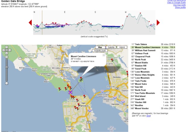
Ogle Earth finds another gem in the form of HeyWhatsThat.com, which uses the SRTM data that is available with GE, to perform viewshed calculations. It can output directly to Google Maps, where it draws a 360 degree panorama that interacts with the google map interface. It also identifies the peaks visible from your position, and you can highlight the entire viewshed in red.

You can also import the entire set into Google Earth, to, I suppose test if the algorithm is correct. Very very cool.

Another useful thing I saw related to education, was a post on slashgeo.org concerning the use of Skype to control virtual globes on another computer. Unype allows two (or more?) users to interact with each others globe, showing them around, and so on. GE Blog reviews and also has a video.

But anyway, after having criticised the Gazetteer for Scotland in an earlier post, I suppose I had better make amends! I was of course referring to the village of Dull in Perth and Kinross. *cough*

I did some work getting XLST to work today, with limited success. I did after hacking up a quick XML sample of one of the Gazetteers pages, manage to reproduce a html document with some images from that XML source using XLST. The plan is to produce some samples for use in my presentation on Monday, perhaps an html document with two seperate stylesheets, and maybe KML, to demonstrate how powerful XSLT can be.

The only major problem I've had is in my search for a good editor. I decided to start off simple with Microsoft's XML Notepad 2007 . At first glance it did exactly what I wanted it for, but it has some really annoying bugs, especially that you need to close and re-open the XSLT stylesheet everytime you want to re-transform (the copy must be cached inside). So that was useless.

I then tried Oxygen. This was complete at the other end of the scale. Not only do I just get a 30 day trial, but it's also so incredibly complex with so much functionality that I really don't need. Having said that, it worked quite nicely if you ignore _all_ the functions and just use it as an editor, and as a tool for running the XSLT.

Anyone have better suggestions?

Labels: , , , , ,

Sunday, 11 February 2007

Uni work, Yahoo Pipes and some Apps

It's all gone a little bit quiet on the blog front, which is just as well as I'm having trouble finding the time to stay updated!

At uni, we're delving into a wide range of things, and with teaching now complete it means I'm finishing a whole bunch of projects. These include extending a java Lotka-Volterra model integrated with a Cellular Automate for my environmental modelling project. Finishing a database project that requires us to use HTML to SVG interaction, and running perl scripts to generate SVG directly from a Oracle Spatial Database. Yes, sometimes it feels like it is as complex as it sounds. Then I have an ontology project to finish, whereby we as a group are trying to model a geographic process with an ontology and be able to reasoning with and upon it. I've been playing with some of the stuff at Mindswap.org including their Pellet reasoner, but it's all very complex stuff with barely an example to take inspiration from.

Then I have a project on KML to finish, whereby I'm going to extend one of it's capabilities or address a problem. Not too sure where I am on that yet. Then finally, I need to try and explore the use of virtual worlds to aid teaching. Hmm. And all this on a GIS course. Haven't used an ESRI product for months!

Anyways, the big news I suppose is the launch of the Yahoo Pipes service. I haven't had time to use it myself, but the GE blog discusses it's implications for Google Earth/Map. In many ways this is kind of related to some of the OWL ontology work we are doing now, but on a lower level. Pipes allows you to take the output of other websites, combine/analyse relative to other data or parameters and displays it in some way. It's simple drag and drop editor interface, will appeal to those who aren't complete techies.The Guardian however isn't convinced.

Why pipes? Well, it's probably named after the Unix | character that lets you use/pipe the output of one thing in another. It's certainly an interesting idea, and allows potential novices to do things with data feeds that in the past have been the domain of the programmer only. KML support is also coming.

New Version of World Wind due this Wednesday, according to earth is square Yes Valentines day. Looking forward to it :)

The Chinese are getting in on the virtual globe act too, reports Ogle Earth. Looks like it will be proprietary though.

Finally, James Fee does a great example of how to combine a range of services to do some interesting practical applications - finding a new home!

Labels: , , , , ,

Thursday, 11 January 2007

Bits and pieces + dissertation proposal

First of all - doing a course on geo-informatics and one of my coursemates pointed to an excellent flash movie explaining the many dimensions of our universe. It appears roughly adapted from the text we were prescribed by Abbott (1884).

Second, my dissertation proposal is due in fairly shortly, and I've decided to proceed along the lines of converting an online gazzeteer into XML data format, and provide some kind of interface and front ends for this data. This could be in the format of the older traditional website which could be 'cleaned' up, but perhaps more interestingly by providing mechanisms to some of the other means we have for disseminating information. Google Earth, and it's virtual globe peers, seem a good place to start, so one of the interesting projects would be to write some kind of XML to KML conversion.

On the blog front, several blogs reported and commented on the news of digital globe buying globe explorer. Which is interesting as the former is a major provider of data to google, while the other provides to Microsoft. Interesting..

Oh and the earth is square blog found this fantastic little terrain modelling, play gadget! brilliant!

Labels: , , , , , ,